A fresh breeze from the northeast is keeping temps down across Georgia for several more days. You will feel it this afternoon, even with a few pop-up storms around.
🌡️ What It Means For You: Highs stay in the low to mid 80s through the weekend, with mornings in the upper 60s. That means cooler walks, lower power use, and a break from sticky air. Keep rain gear close for a brief shower or thunderstorm, mainly in the afternoon and evening.
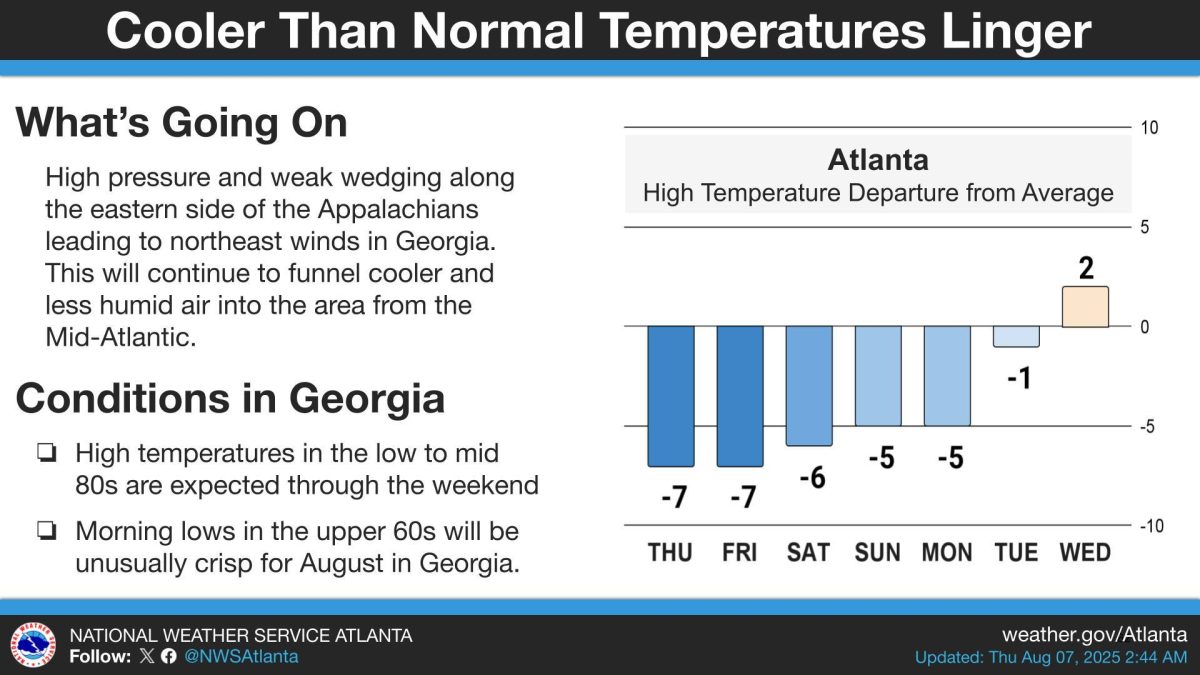
🌬️ What’s Happening: High pressure is wedging cool, dry air down the eastern side of the mountains, pushing Mid-Atlantic air into Georgia on east-northeast winds.
- This pattern holds into early next week.
- Atlanta’s highs run about 5 to 7 degrees below normal into Monday, then near normal by Tuesday and slightly warmer by Wednesday.
⛈️ Between The Lines: Storms will be isolated to scattered, not a washout.
- Any storm can bring brief downpours, lightning, and gusty wind. When thunder roars, head indoors.
🗺️ The Big Picture: For August, this is unusual. We’re used to heat and haze. This setup knocks back heat and humidity without a strong cold front, a reminder that local wind patterns around the Appalachians can reshape summer weather here.
The Sources: National Weather Service.
🛑 🛑 🛑
Before You Dismiss This Article…
We live in a time when information feels overwhelming, but here’s what hasn’t changed: facts exist whether they comfort us or not.
When A&W launched their third-pound burger to compete with McDonald’s Quarter Pounder in the 1980s, it failed spectacularly. Not because it tasted worse, but because customers thought 1/3 was smaller than 1/4. If basic math can trip us up, imagine how easily we can misread complex news.
The press isn’t against you when it reports something you don’t want to hear. Reporters are thermometers, not the fever itself. They’re telling you what verified sources are saying, not taking sides. Good reporting should challenge you — that’s literally the job.
Next time a story makes you angry, pause. Ask yourself: What evidence backs this up? Am I reacting with my brain or my gut? What would actually change my mind? And most importantly, am I assuming bias just because the story doesn’t match what I hoped to hear.
Smart readers choose verified information over their own comfort zone.

B.T. Clark is an award-winning journalist and the Publisher of The Georgia Sun. He has 25 years of experience in journalism and served as Managing Editor of Neighbor Newspapers in metro Atlanta for 15 years and Digital Director at Times-Journal Inc. for 8 years. His work has appeared in several newspapers throughout the state including Neighbor Newspapers, The Cherokee Tribune and The Marietta Daily Journal. He is a Georgia native and a fifth-generation Georgian.
- B.T. Clark

- B.T. Clark

- B.T. Clark

- B.T. Clark