

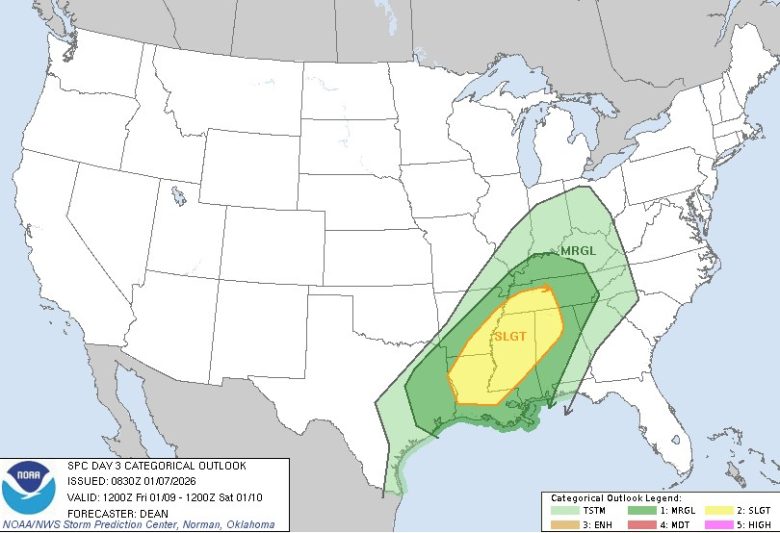
Parts of Georgia are under a marginal risk for severe weather as a storm system moves through the state Friday afternoon into Saturday, according to the National Weather Service.
What’s Happening
The Storm Prediction Center has issued a Marginal Risk — Level 1 out of 5 — for portions of Georgia beginning Friday afternoon and continuing through Friday night, possibly into early Saturday morning.
A marginal risk means isolated severe storms are possible, but not all areas will see severe weather.
What’s Important
The system could bring:
- Isolated strong to severe thunderstorms
- Gusty, damaging winds
- Heavy rainfall that may cause localized flooding in low-lying areas or places with poor drainage
- A brief tornado, particularly with stronger storms
Storm chances increase Friday afternoon and evening.
What Changed
The Storm Prediction Center map shows a yellow “SLGT” (slight risk) zone covering parts of Alabama, Mississippi, and Tennessee, with a broader green “MRGL” (marginal risk) area extending into Georgia.
What We Know
The Carroll County Sheriff’s Office of Emergency Management issued the alert Thursday, urging residents to stay weather-aware.
The National Weather Service and Storm Prediction Center are continuing to monitor the system as it develops.
What’s Still Unknown
Exactly which areas will see the strongest storms remains unclear.
The forecast may shift as the system approaches.
- Have you seen these three missing Georgia teens
- Driver dies after runaway tire hits two cars on I-75
- 76-year-old ex-wife charged with murder after two people were found dead in a Georgia home
- Georgia Supreme Court sends child neglect case back to lower court
- Wildfire danger is high across much of Georgia today