
AccuWeather hurricane experts say exceptional warmth in the Gulf is raising the risk of rapid intensification later this month, heightening the danger if tropical storms or hurricanes develop or move into the region.
“Atmospheric conditions will be primed for tropical storms and hurricanes to develop by mid-September,” AccuWeather Lead Hurricane Expert Alex DaSilva explained. “AccuWeather hurricane experts predict less dry air, Saharan dust, and disruptive wind shear across much of the main development region in the Atlantic and the Gulf.”
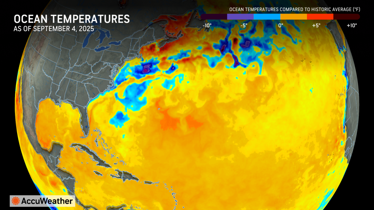
The Gulf has been virtually untouched this hurricane season, with short-lived Tropical Storm Barry forming in the Bay of Campeche in June being the only named storm to impact the Gulf this year. The absence of tropical activity has allowed the water to become incredibly warm, priming the Gulf for fast-developing storms.
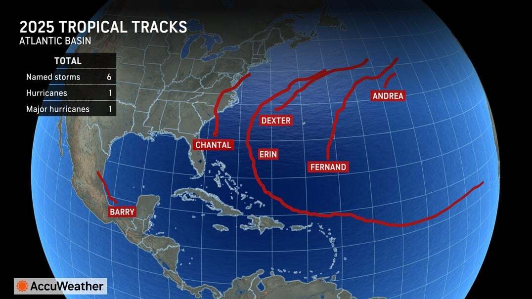
“Hurricanes Beryl and Debby, as well as tropical storms Alberto and Chris, all tracked through the Gulf before September last year. So far this year, tropical storm Barry is the only storm that moved through the Gulf,” DaSilva explained. “Barry formed in the Bay of Campeche in late June and made landfall in Mexico along the southern Gulf. Waters in the central and northern Gulf have not been disturbed by a storm yet, allowing temperatures to skyrocket to near record levels.”
Warm water can act as fuel for hurricanes. The Gulf is currently like a giant bathtub with water temperatures in the upper 80s to low 90s.
“If anything goes in there, it almost certainly will become a major hurricane. The ocean heat content, or the depth of warm ocean water in the Gulf and western Caribbean, is near record high levels,” DaSilva said. “This is extremely concerning.” 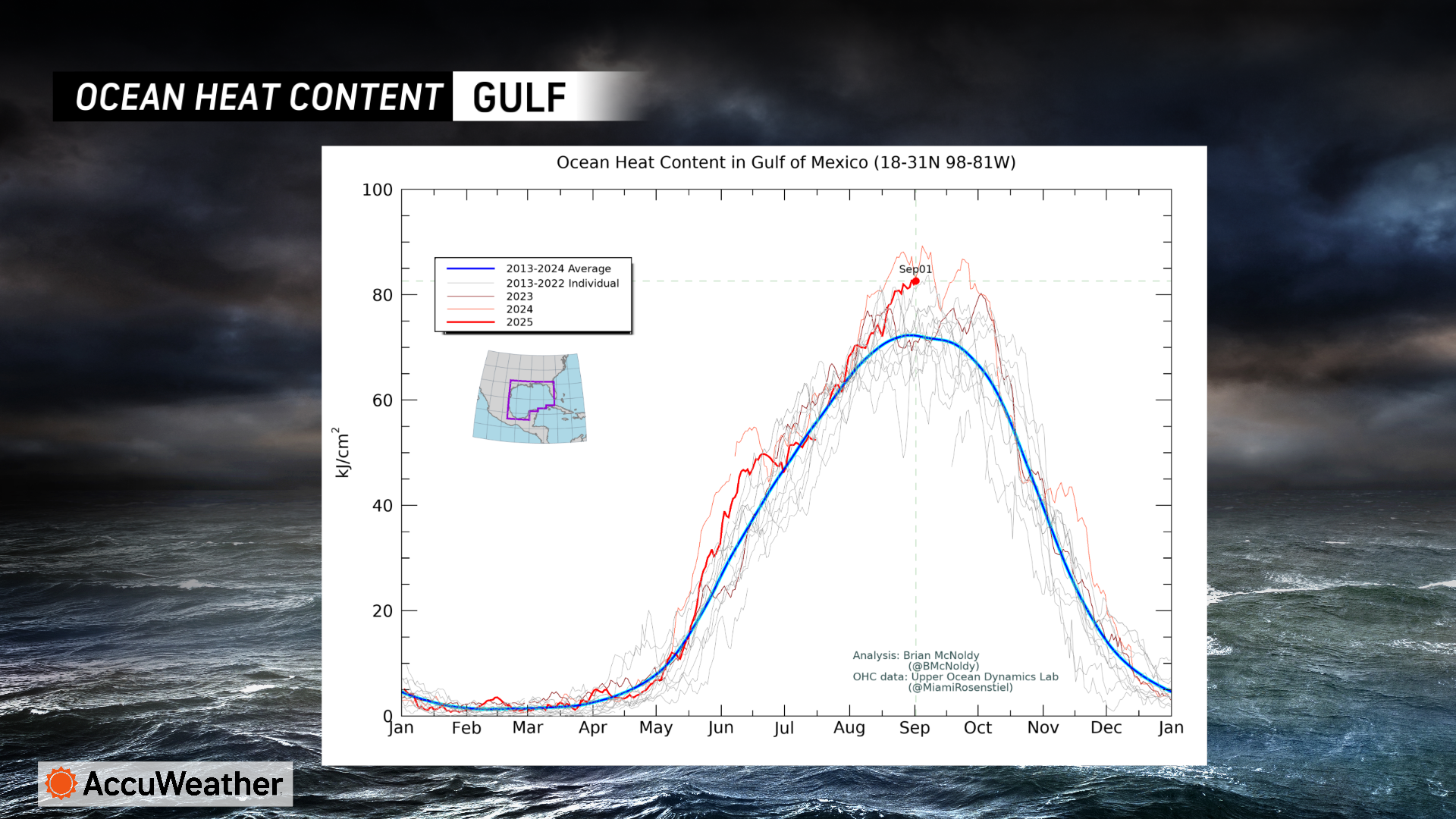
Rapid intensification has become more common in the Gulf in recent years, with catastrophic hurricanes Helene, Ian and Michael all quickly strengthening as they approached land.
“Storms that rapidly intensify near the coast leave people, businesses, and officials with less time to react, prepare, and evacuate. We have been encouraging people since the beginning of the hurricane season to stock up on emergency supplies, check their insurance policies, and take time to review local evacuation zones and evacuation routes,” DaSilva said. “It takes time to board up buildings, open emergency shelters, and set up evacuation contraflow. Rapidly intensifying storms can leave people with little time to react, so preparation is key.”
Hurricane Erin was the latest example of rapid intensification in the Atlantic basin. Last month, Erin’s maximum sustained winds increased a staggering 85 mph within 24 hours, allowing the storm to explode in the warm waters from a Category 1 hurricane to a Category 5 hurricane.
“Erin is the latest case of extreme rapid intensification, when maximum sustained winds increase 58 mph or more within 24 hours,” DaSilva said.
In the AccuWeather 2025 Atlantic Hurricane Season Forecast, which was issued in March, AccuWeather hurricane experts highlighted areas along the Texas, Louisiana, Mississippi and Florida Gulf coast as regions with a higher-than-average risk of a direct impact this year.
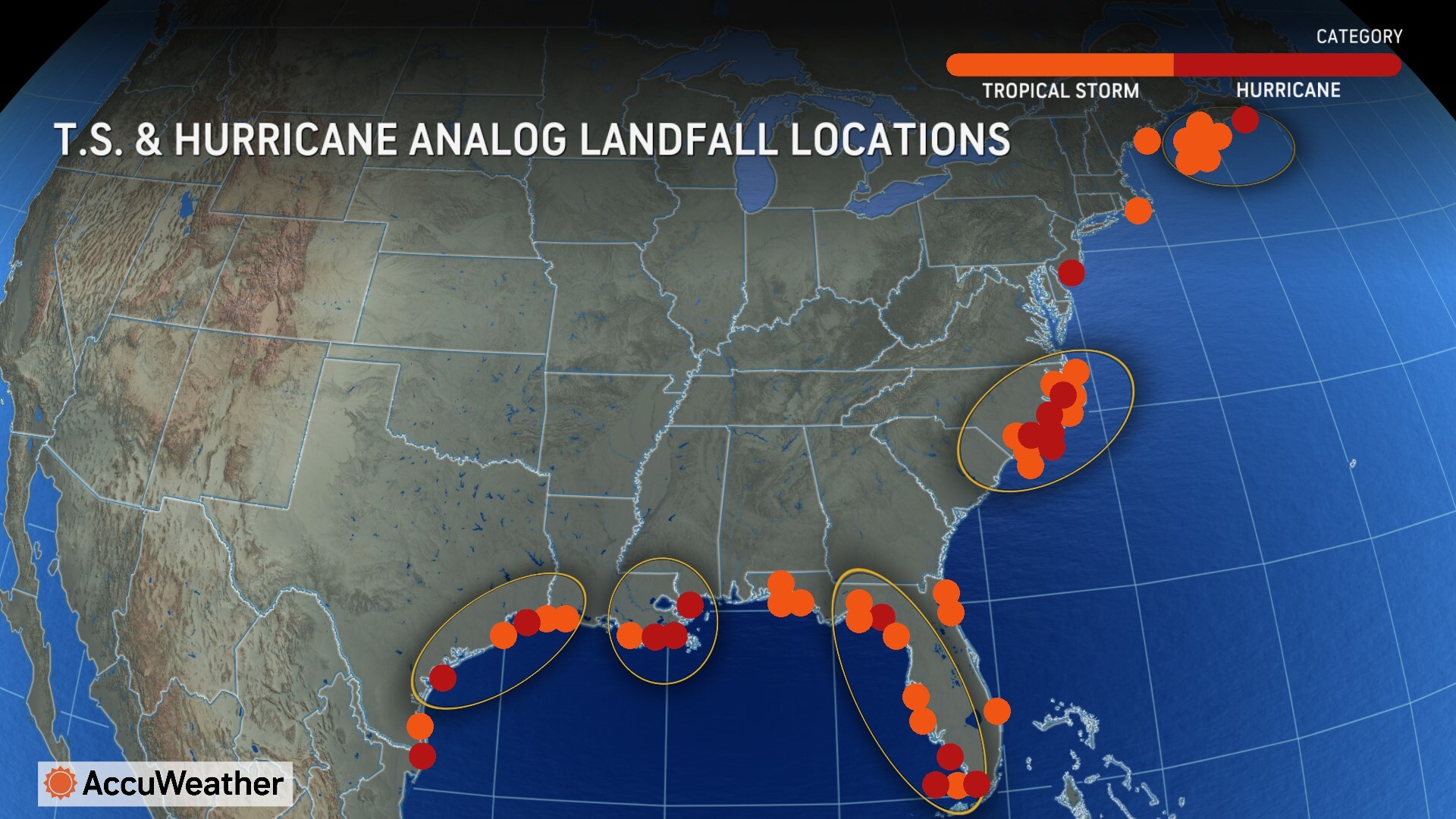
Atlantic Canada, the North Carolina coastline, the northeastern Caribbean, Puerto Rico and the United States Virgin Islands are also at an increased risk of direct impacts this season.
The climatological peak of the Atlantic hurricane season is next Wednesday, Sept. 10. AccuWeather® hurricane experts predicted in March that the second half of the season would have more named storms than the first half of the season.
The AccuWeather® 2025 Atlantic Hurricane Season Forecast predicts 13 to 18 named storms, including seven to 10 hurricanes and three to five major hurricanes that reach Category 3 strength or higher on the Saffir-Simpson Hurricane Wind Scale. A Category 3 hurricane has sustained winds between 111 and 129 mph.
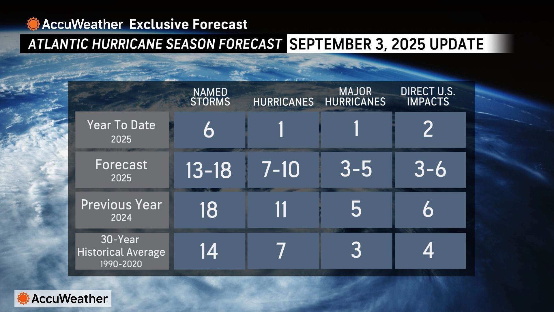
AccuWeather is forecasting three to six direct impacts to the U.S. this year, which is the same range AccuWeather® forecast for the historic 2024 Atlantic hurricane season. AccuWeather® was the first known source to issue an Atlantic hurricane season forecast in March.
AccuWeather hurricane experts issued an update in May, urging people, businesses, officials and emergency responders to prepare for an increased risk of flooding and tornado impactsreaching far inland after landfall, similar to last year.
🛑 🛑 🛑
Before You Dismiss This Article…
We live in a time when information feels overwhelming, but here’s what hasn’t changed: facts exist whether they comfort us or not.
When A&W launched their third-pound burger to compete with McDonald’s Quarter Pounder in the 1980s, it failed spectacularly. Not because it tasted worse, but because customers thought 1/3 was smaller than 1/4. If basic math can trip us up, imagine how easily we can misread complex news.
The press isn’t against you when it reports something you don’t want to hear. Reporters are thermometers, not the fever itself. They’re telling you what verified sources are saying, not taking sides. Good reporting should challenge you — that’s literally the job.
Next time a story makes you angry, pause. Ask yourself: What evidence backs this up? Am I reacting with my brain or my gut? What would actually change my mind? And most importantly, am I assuming bias just because the story doesn’t match what I hoped to hear.
Smart readers choose verified information over their own comfort zone.

B.T. Clark
B.T. Clark is an award-winning journalist and the Publisher of The Georgia Sun. He has 25 years of experience in journalism and served as Managing Editor of Neighbor Newspapers in metro Atlanta for 15 years and Digital Director at Times-Journal Inc. for 8 years. His work has appeared in several newspapers throughout the state including Neighbor Newspapers, The Cherokee Tribune and The Marietta Daily Journal. He is a Georgia native and a fifth-generation Georgian.
