
Tropical Storm Erin is far out in the central Atlantic and poses no immediate threat to Georgia, but forecast changes later this week could influence coastal surf and rip current risk along the Georgia coast late next week if the storm tracks farther west before turning.
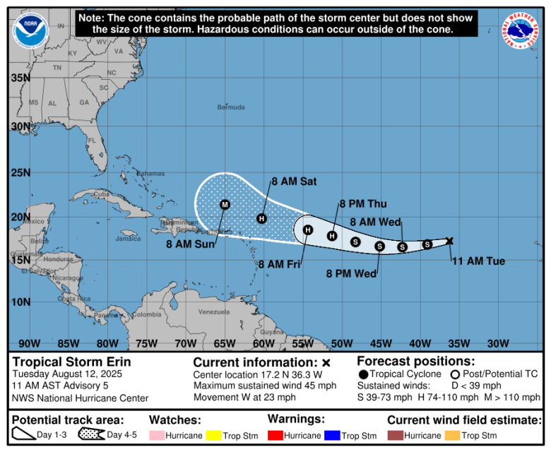
Current Status: As of 11 a.m. Tuesday, Aug. 12, the National Hurricane Centerestimated Erin’s top sustained winds at 45 mph with a fast westward motion near 20 knots. Satellite and scatterometer data show a well-defined low-level circulation but limited thunderstorm activity, which has capped strengthening so far.
Track Outlook: Guidance keeps Erin moving generally west through early Thursday under strong Atlantic high pressure. After that, a weakness in the ridge should nudge the system west-northwest, but models disagree on when and where that turn sets up. Several deterministic models and ensembles shifted south and west compared with earlier runs, a trend the the National Hurricane Center incorporated into its latest track. Some solutions are even farther south.
Intensity Outlook: From late Wednesday into Thursday, Erin moves into warmer water and a more favorable atmosphere, and it could become a hurricane by late Thursday. The forecast shows continued strengthening, with the system potentially reaching major hurricane intensity by early Sunday. Confidence in intensity is lower than average because model spread remains large.
Timeline and scenarios for Georgia
- Through this weekend: No direct impacts to Georgia. Erin will be near or east of the northeast Caribbean longitudes by Saturday and Sunday if the current timing holds.
- Early to mid next week (most likely window for any Georgia effects):
- Offshore recurvature (most common outcome in similar patterns): If the turn occurs on the earlier/eastern side, Georgia’s main effect would be longer-period swells and elevated rip current risk along the coast late next week.
- Farther-west track toward the Bahamas/Florida first: If the ridge stays stronger longer, the storm could get closer to the Bahamas before turning. That scenario would raise attention for coastal Georgia, primarily for surf and rip currents, and potentially inland rain, gusty winds and a low-end tornado risk in outer rainbands if any remnants or a recurving system lift north.
- Greater Antilles interaction: A track across or near the Greater Antilles could disrupt the core and alter both timing and intensity before any approach to the Southeast.
At this range, Georgia’s risk profile hinges on the timing and latitude of Erin’s west-northwest turn. The earliest practical window for coastal effects is the middle to latter part of next week.
A Note About The Cone: The hurricane center cone depicts the probable path of the storm’s center, not the breadth of hazards. Rip currents and surf can increase along the Georgia coast even when the center remains hundreds of miles offshore. Areas outside the cone are not guaranteed to be impact-free.
Preparedness reminders
- Now, before any watches are posted, review coastal evacuation zones and flood plans, especially in low-lying areas and along tidal rivers and sounds.
- Mariners and beach communities should monitor guidance on swells and rip current risk later next week.
- Follow updates from the National Hurricane Center and local National Weather Service offices; forecast adjustments are likely as new data arrive over the next 2 to 4 days.
Bottom line for Georgia: Erin is a watch-and-wait system. There is no immediate threat, but if the storm delays its turn and tracks farther west, coastal hazards could increase late next week. Keep routine hurricane-season readiness steps in place while monitoring official forecasts.
🛑 🛑 🛑
Before You Dismiss This Article…
We live in a time when information feels overwhelming, but here’s what hasn’t changed: facts exist whether they comfort us or not.
When A&W launched their third-pound burger to compete with McDonald’s Quarter Pounder in the 1980s, it failed spectacularly. Not because it tasted worse, but because customers thought 1/3 was smaller than 1/4. If basic math can trip us up, imagine how easily we can misread complex news.
The press isn’t against you when it reports something you don’t want to hear. Reporters are thermometers, not the fever itself. They’re telling you what verified sources are saying, not taking sides. Good reporting should challenge you — that’s literally the job.
Next time a story makes you angry, pause. Ask yourself: What evidence backs this up? Am I reacting with my brain or my gut? What would actually change my mind? And most importantly, am I assuming bias just because the story doesn’t match what I hoped to hear.
Smart readers choose verified information over their own comfort zone.

B.T. Clark
B.T. Clark is an award-winning journalist and the Publisher of The Georgia Sun. He has 25 years of experience in journalism and served as Managing Editor of Neighbor Newspapers in metro Atlanta for 15 years and Digital Director at Times-Journal Inc. for 8 years. His work has appeared in several newspapers throughout the state including Neighbor Newspapers, The Cherokee Tribune and The Marietta Daily Journal. He is a Georgia native and a fifth-generation Georgian.
