
Severe thunderstorms are expected to roll through North Georgia on Monday afternoon and into the overnight hours, bringing the risk of damaging winds, a brief tornado, and flooding.
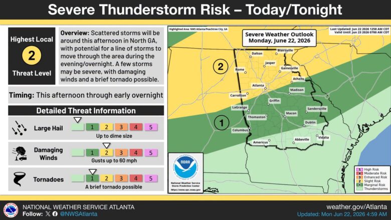
What’s Happening: The National Weather Service has placed North Georgia under a Slight Risk for severe weather, rated 2 on a scale of 1 to 5. Storms are expected to develop this afternoon, with a stronger line of storms possible in the evening and overnight. The busiest stretch is forecast between 6 p.m. and 2 a.m.
Specific threats:
- Wind gusts up to 60 mph
- Hail up to dime size
- A brief tornado, most likely in northwest Georgia
Flooding risk: Heavy rain is also possible, especially if storms keep moving over the same areas. That pattern can dump a lot of rain quickly and lead to street flooding or flash flooding. The National Weather Service says northwest and far north Georgia face the highest flooding risk through tonight.
What This Means for You: The most dangerous window runs from 6 p.m. to 2 a.m. If you are in northwest or far north Georgia, stay off low-lying roads and away from areas that flood easily during that time.
The Path Forward: The forecast is valid until 7 a.m. Tuesday. Updated information is available at weather.gov/Atlanta.
I attempted to venture outdoors the other night and was promptly attacked by mosquitoes — adding to my plight. I wonder which Biblical plague I’ll be experiencing next week. Knowing Georgia’s weather, I’m betting on hail.
 Buy the Book on Amazon →

B.T. Clark is an award-winning journalist and the Publisher of The Georgia Sun. He has 25 years of experience in journalism and served as Managing Editor of Neighbor Newspapers in metro Atlanta for 15 years and Digital Director at Times-Journal Inc. for 8 years. His work has appeared in several newspapers throughout the state including Neighbor Newspapers, The Cherokee Tribune and The Marietta Daily Journal. He is a Georgia native and a fifth-generation Georgian.
- B.T. Clark

- B.T. Clark

- B.T. Clark

- B.T. Clark

- Body found near dumpsters at Augusta business
- Duluth speed demon hits 104 mph and gets nowhere fast
- Glynn County students must keep phones off and out of sight all day starting this fall
- ROACH BRUNCH: Georgia IHOP crawling with live bugs scores 64
- HATE WAVE: 4 charged in year-long antisemitic terror spree across Georgia
