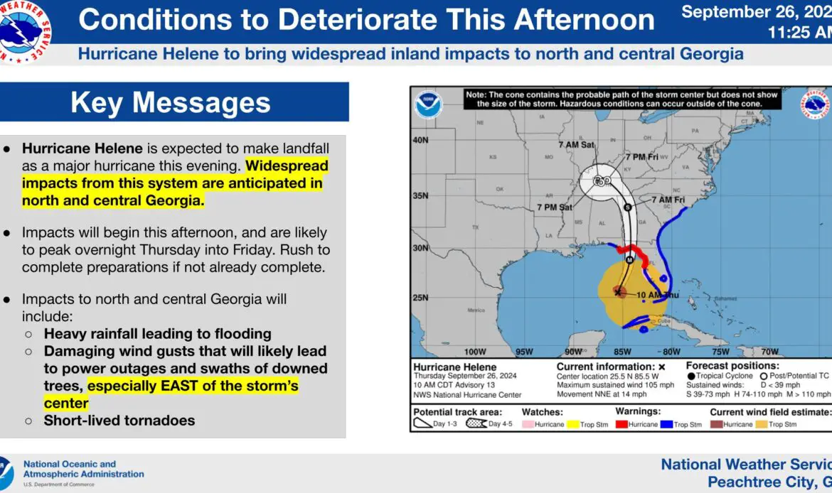
Hurricane Helene is poised to make landfall tonight as a major hurricane, bringing dangerous weather to residents in north and central Georgia. The National Weather Service has warned that widespread impacts from this storm system will be felt across much of the state, particularly with high winds, heavy rain, and potential flooding.
The Details: The weather service reports that impacts will begin this afternoon and are expected to intensify through the night, peaking between Thursday night and early Friday morning. Residents across Georgia are urged to complete their preparations as quickly as possible, with many areas already under watches and warnings. Meteorologists have warned that those in the path of the storm should brace for extreme conditions, especially to the east of the storm’s center, where the effects will be most severe.
By The Numbers:
- There is an 80-90% chance that much of the state will experience tropical-storm-force winds, ranging from 39 mph to 73 mph.
- Heavy rainfall is expected across the region, with localized flooding a major concern for low-lying areas.
- Wind gusts strong enough to knock down trees and cause power outages will likely occur, particularly east of the storm’s center.
- Tornadoes could spin up quickly, adding another layer of danger to the situation.
In Context: As Helene tracks northward, the exact path of the storm will dictate the severity of the impact. The eastern side of the storm, typically the most dangerous, is predicted to hit some of Georgia’s most populated areas. While minor adjustments in the storm’s trajectory could influence which communities experience the most damage, the overall expectation is that many areas will be affected. Emergency management officials are advising residents in potentially impacted regions to prepare for significant disruption, with power outages expected to last for days in some areas.

Why It Matters: Georgia has not faced a storm of this magnitude in several years, and the inland nature of Helene’s impact poses a serious risk of flooding, property damage, and power outages far beyond the usual areas that see hurricane activity. As winds pick up, the likelihood of fallen trees and blocked roads will increase, which could make emergency response difficult. The major threat is flooding. The storm will dump several days worth of rain on the state with up to 18 inches expected in some areas.
How You Can Help: Residents in Georgia can take steps to ensure their safety by following a few key guidelines:
- Secure outdoor furniture, trash cans, and other loose items that could become projectiles.
- Charge all necessary devices and stock up on essential supplies, including food, water, and medical items.
- Keep up to date with local advisories and evacuation notices. Those in low-lying or flood-prone areas should be prepared to move to safer ground if necessary.
What’s Next: Forecasters are closely watching the storm’s progress as it moves inland. Though Georgia will likely bear the brunt of Helene’s force, other states in the Southeast may also experience dangerous weather. Keep an eye on local updates and be ready for changes in the storm’s track. Officials will continue to monitor the situation closely and advise residents accordingly.
[mailerlite_form form_id=13]