
Get ready for the possibility of more impactful winter weather. That’s the message for Americans living in parts of the eastern United States who just dealt with a major winter storm that dropped more than a foot of snow in some places.
AccuWeather forecasters on Monday were watching for more chances of snow and other wintry weather to break out across portions of the eastern United States, just after a winter storm spent the weekend making a mess of places from the Tennessee Valley through the Southeast and up the Eastern Seaboard into New England.
Another wave of Arctic air will advance southeastward from Canada Wednesday into Thursday following a fleeting stretch of higher temperatures that will provide the chance for a minor thaw in some of the storm-hit regions.
Typically, the leading edge of the cold air, or cold front, produces a period of rain then dry air takes hold. But, in some cases, the cold air can catch up with the backside of the rain and cause that precipitation to change to sleet or a mix of sleet and snow. And, particularly when a weak storm begins to form along the front, the atmosphere can take the changeover a step farther and trigger snowfall that can be significant enough to accumulate across a narrow zone, which is precisely the chain of events that could unfold in the days ahead.
“The energy for this storm was moving onshore along the Pacific coast on Monday, and if that catches up to the front a certain way, there could be a narrow, sneaky zone of 3 inches of snow from parts of the Tennessee Valley to the lower mid-Atlantic coast in the Wednesday night to Thursday time frame,” AccuWeather Chief On-Air Meteorologist Bernie Rayno said.
The timing for the changeover seems likely from Tennessee and Kentucky to West Virginia during Wednesday night and may extend into the northern parts of Mississippi and Alabama as well. Spotty rain and snow showers associated with the frontal passage are likely across northern Maryland, Pennsylvania, northern New Jersey and the rest of the Northeast during Wednesday night.
Even in areas that simply experience a period of rain, rain showers or non-accumulating snowflakes, plunging temperatures can cause untreated wet and slushy areas to freeze with slippery spots on roads, sidewalks and parking lots.
On Thursday, the same brief changeover setup can stretch from parts of western North Carolina to northern and western Virginia, central and southern Maryland, central and southern Delaware and southern New Jersey. Since temperatures are likely to fall at a slower pace across this region, when compared to areas west of the Appalachians, there is a much lower chance for an inch or two of snow to fall. However, AccuWeather forecasters caution that even a small amount of snow can cause major trouble for motorists and pedestrians.
And after that episode of winter weather, another one could be following in short order.
Dropping temperatures could usher in another wintry punch
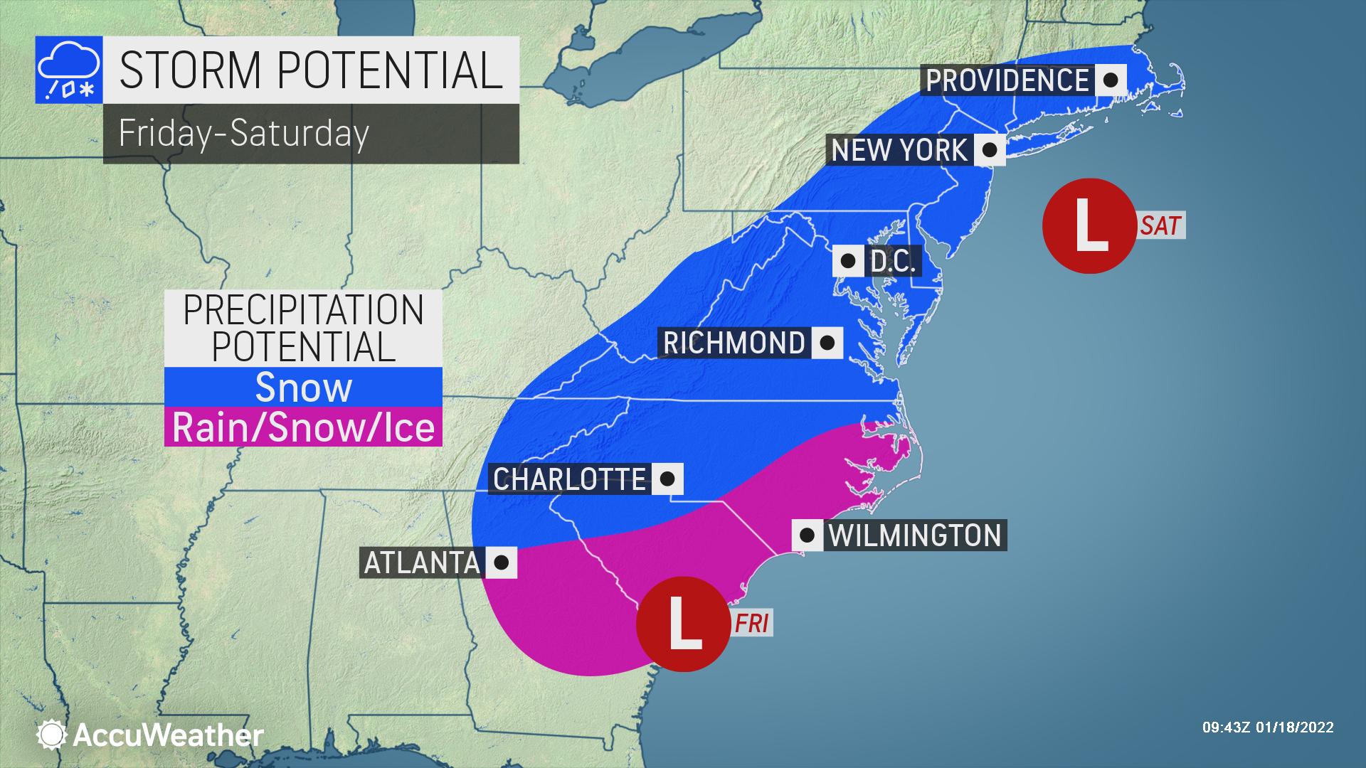
“This isn’t the only storm we have to watch this week,” Rayno warned, adding that there is room for a larger storm to form in the Southern states on Friday along the front and potentially move northward along the Atlantic coast during Friday night and Saturday.
“There will be another fresh injection of Arctic air into the Northeast late this week, and as we have seen with this last storm, that can set the stage for a significant storm to unfold,” Rayno said.
Late this week, temperatures are forecast to dip as low as, or even a few degrees lower, than they did early last weekend ahead of the winter storm that just moved through. Last weekend, temperatures plunged sharply across the eastern U.S. as the mercury bottomed out at 28 degrees below zero in the Adirondacks of northern New York state this past Sunday morning ahead of the storm’s arrival.

Other places endured unusual cold as well.
For the first time in 1,078 days, the temperature dipped below 20 F at Washington Reagan National Airport, D.C., on Sunday morning. The low was 17 degrees. The old record was 428 days set in 2001-2002.
Charlotte has dipped into the low to mid-20s on a few occasions so far this month. By Saturday morning, temperatures could dip into the lower 20s in the Queen City again, which could eclipse the season low so far of 23 there. Temperatures are also forecast to drop into the lower 20s Tuesday morning.https://playlist.megaphone.fm/?p=ACC3051914128&episodes=1
A key weather factor in determining if another major storm develops along the Atlantic seaboard will be the jet stream and how far west its southward dip will reach.
“Should the jet stream dip set up right along or just off the coast, then the storm would more likely be swept out to sea before heading very far north on the Atlantic seaboard early this weekend,” Rayno explained.
CLICK HERE FOR THE FREE ACCUWEATHER APP
But if the jet stream dip hangs back a bit toward the Appalachians, high pressure over New England may block the path and prevent the storm from escaping out to sea.
“In that case, the storm would tend to climb northward along the coast with the potential for snow or a wintry mix combination along the Interstate-95 corridor of the mid-Atlantic and New England,” Rayno said.
The storm would not be able to track so far west as to spread heavy snow up the spine of the Appalachians and into parts of the Ohio Valley and eastern Great Lakes region like the storm from Sunday to Monday was able to do.
People from Washington, D.C., to Philadelphia, New York City and Boston should monitor the weather forecast as any storm that develops could move up from the south Friday night into Saturday.
For people in areas from Georgia to the Carolinas, Virginia, Delaware, Maryland and southern New Jersey, there is the potential for enough snow, or a mix of snow and ice, to cause travel problems once again between Friday and early Saturday.
Wintry travel and delays could spring up again along portions of interstates 20, 26, 40, 77, 81, 85 and 95. Airline passengers with flights leaving from, arriving in or connecting through the major southern U.S. hubs of Atlanta and Charlotte could also face disruption from the storm.
Should the storm end up taking a more southern route, an icy or wintry mix could occur all the way to the coastal areas of the Carolinas, Georgia and Virginia, instead of all rain, which is more typical for this time of year.
And the weather pattern will remain active afterward.
There will likely be additional storms with areas of snow and ice every several days that come about over the next couple of weeks at least. “The pattern is ‘loaded’ with three wintry opportunities in the Eastern states over the next seven days,” Rayno said.