
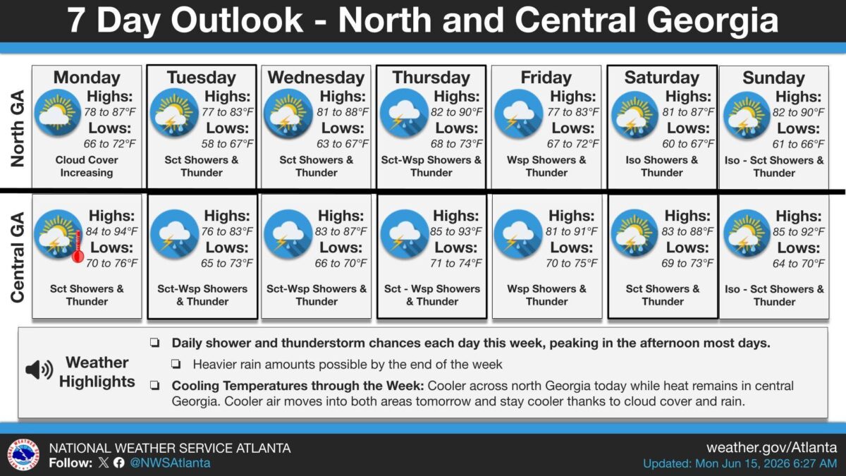
People across north and central Georgia should expect afternoon and evening thunderstorms every day this week, with temperatures slowly falling as clouds and daily rain settle in.
What’s Happening: Monday starts differently depending on where you are. North Georgia is cooler and drier, with highs between 78 and 87°F and clouds building but no rain in the forecast yet. Central Georgia is already warm and muggy, with highs reaching 84 to 94°F and scattered showers and thunderstorms already possible.
The Week Ahead: Cooler air pushes into both regions Tuesday and sticks around, held in place by cloud cover and daily rain. Thunderstorm chances are in the forecast every single day through Sunday. The heaviest rain is expected later in the week, especially Thursday and Friday, when widespread storms are forecast across both regions.
- North Georgia highs will range from the upper 70s to low 90s, with overnight lows dipping as cool as 58°F Tuesday night.
- Central Georgia highs will range from the mid-70s to low 90s, with lows mostly in the mid-60s to mid-70s.
- Storms are most likely in the afternoon on most days.
- Friday brings the most widespread storm coverage of the week in both regions.
What This Means for You: Any outdoor plans in the afternoon or evening carry a storm risk every day this week. Thursday through Friday bring the best chance of heavier rain and higher rainfall totals.
The Path Forward: The pattern holds through the weekend, with Sunday bringing isolated to scattered showers and thunder across both north and central Georgia.

B.T. Clark is an award-winning journalist and the Publisher of The Georgia Sun. He has 25 years of experience in journalism and served as Managing Editor of Neighbor Newspapers in metro Atlanta for 15 years and Digital Director at Times-Journal Inc. for 8 years. His work has appeared in several newspapers throughout the state including Neighbor Newspapers, The Cherokee Tribune and The Marietta Daily Journal. He is a Georgia native and a fifth-generation Georgian.
- B.T. Clark

- B.T. Clark

- B.T. Clark

- B.T. Clark

- Body found in car matches description of missing Macon-area woman
- Boil water advisory issued for four Effingham County neighborhoods tonight
- 6 people were rescued from the Chattahoochee River after their raft broke away
- Georgia has tried for years to fix its teacher shortage. It's getting worse
- We The People: Why The Constitution's First 52 Words Still Matter Today
