
A line of storms will move from Alabama into western Georgia this evening and push east overnight, the National Weather Service in Peachtree City said Monday.
What’s Happening: The storm line is expected to bring damaging wind gusts as the main threat. Quarter-size hail and a brief spin-up tornado are also possible.
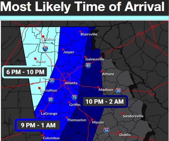
What’s Important: The National Weather Service rated the highest local threat at Level 2 out of 5, which is called a “Slight Risk.” The greatest chance of severe weather runs from 6 p.m. to 2 a.m..
By the Numbers:
- Wind gusts up to 60 mph possible
- Hail up to quarter size possible
- Tornado threat rated Level 1 out of 5
The Timeline: Storm arrival times vary by location. Northwest Georgia, including Rome and Dalton, can expect storms between 6 and 10 p.m.. Atlanta and the surrounding area should see storms between 9 p.m. and 1 a.m. Areas east of Atlanta, including Gainesville and Madison, are expected to see storms between 10 p.m. and 2 a.m. The line is expected to weaken as it moves east.
How This Affects Real People: Residents across central and western Georgia should be prepared for the possibility of damaging winds, large hail, and a brief tornado during the overnight hours.
