
Tennessee State Climatologist Dr. Andrew Joyner of Eastern Tennessee State University said the events will grow more frequent and more intense in the coming years. Joyner, who is helping state and local governments throughout Appalachia plan emergency mitigation strategies, said states and communities in the region need to be prepared to handle extreme weather over the next 10 to 15 years.
“The big picture is we are getting warmer and wetter,” Joyner said in an interview with the Daily Yonder. “We’ve observed that, not even projecting into the future, we see these types of hurricanes increasing in intensity, just like Helene kind of did, and so it points to the increasing chances that we would have more of these events in the future.”
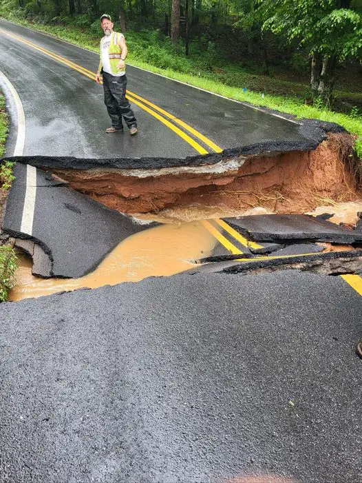
In 2024, Hurricane Helene hit western Tennessee and eastern North Carolina, resulting in heavy flooding and widespread damage to roads, infrastructure, and communities. Weather forecasters said the flooding stemmed in part due to the excessive rain that had fallen in the region the week before the storm blew into the mountains.
It wasn’t the first time it’s happened, he said. In July 1916, another similar extreme event occurred after western North Carolina saw nearly a week of rain. When the weather cleared, instead of a period of hot, dry weather, a hurricane struck Charleston and Mobile, dumping heavy rains on the Great Smoky Mountains. Mitchell County, in the western Piedmont region of the state, recorded 19 inches of rain in 24 hours, according to the North Carolina Department of Natural and Cultural Resources.
The 1916 floods that followed killed an estimated 80 people and damaged nearly all of the railroads west of Winston-Salem and most of the highway bridges across the Catawba and Yadkin rivers. The French Broad River crested at about 21 feet, 17 feet above flood stage, while the Catawba rose almost 21 feet above previous high-water marks.
“The 1916 flood shows that this type of event, or this set-up of events, has happened before and it’s not necessarily unique,” he said. “You have more than 100 years apart that you had those two events, so no one alive today has seen an event of that type happen. They’ll continue to happen as the wetter, warmer weather gives more ingredients for that type of event to happen more often.”
In June of this year, eastern Tennessee saw another flooding event in which torrential rains led to flash flooding. Thunderstorms led to heavy rainfall, a mudslide, and flash flooding, according to the National Weather Service. That flood closed a portion of I-40 in Cocke County near the Tennessee/North Carolina state line.
The National Oceanic and Atmospheric Administration predicts this year will see more hurricanes than last year, forecasting between 13 and 19 named storms, of which between six and 10 will become hurricanes and between three and five will become major hurricanes.
“As we witnessed last year with significant inland flooding from hurricanes Helene and Debby, the impacts of hurricanes can reach far beyond coastal communities,” acting NOAA Administrator Laura Grimm said in a statement earlier this year.
Joyner said current projections are that the region is more likely to see a wetter and warmer climate where intense weather events happen closer together.
“My expectation over the next five, 10 or 15 years is more of these kinds of intense rainfall events interspersed with flash droughts, where you’ll go through a period where you’re not going to get rainfall,” he said. “That’s a real concern, especially for farmers and producers who need to know when these flash drought events are going to happen. Last summer, for Tennessee, we had three different drought events – one in June, one in August, and one in October. The one in June had a big impact on corn crops. The one in August had an impact on soybeans, and the one in October was really impactful on livestock. That kind of erratic, really wet, really dry back-and-forth is probably going to continue.”
Max Dugan-Knight, climate data scientist with Deep Sky Climate, agrees. Deep Sky’s recent report shows similar outcomes even in southern Appalchian states like Mississippi, Georgia, and Alabama, as well as parts of South Carolina, Florida, Texas and Louisiana. The research found that in that region the frequency of extreme hurricane rainfall has increased 300% in the past 40 years. Dugan-Knight said that means rainfall so extreme it only occurred once every 100 years will now happen at least every 25 years. The research also found that the severity of these kinds of event has increased 33%.
“In general, climate change is causing more extreme rainfall across North America so the rest of the Appalachian region is not immune from this trend. Extreme rainfall systems and catastrophic flooding is not new to the Appalachian region, the difference is these are getting more common and more intense,” he said in an email interview with the Daily Yonder.
Climate change is also increasing how long the region will be under the threat of hurricanes.
“It is clear that climate change is extending the length of hurricane season,” he said. “Hurricanes can only form at warm ocean temperatures, which is why the warmest summer months into early Fall is historically the most active period. Ocean temperatures are rising overall, meaning that they become warm enough to support hurricane formation earlier in the season, and they stay warm longer.”
The weather changes will also have an efect on winters, ETSU’s Joyner said. East Tennessee has seen a decrease in winter storms over the past 30 years, he said, but in middle and west Tennessee, winter weather has increased with more ice storms and polar vortex events.
“The number of days where you could experience a freeze has definitely gone down across the whole state, and the timing of those frost freeze days is becoming more erratic… We used to be able to have a set time (where you’d see freeze days) usually into mid-April, but maybe that needs to be moved back into March now,” he said.
Joyner said his office’s mission was not one of advocacy or activism, but to provide data and information that decision makers can use to act on.
“One of the biggest projects that we’ve done is to help Tennessee write their last state hazard mitigation plan, and as part of that, we did all of the risk assessments —really digging into the data,” he said.
“As part of that, we have seen changes over the past number of years in intense precipitation events, in temperature, in severe storms, and in winter weather. So, we will point those documents out, and it’s up to the state or local government to make decisions based on that information.”
From irrigation systems to more flood management systems to less development in flood plains, there are options state and local leaders can take to mitigate the effects of these extreme weather events, he said. And the data suggests that there is a real need for policymakers to take steps to prepare for what a warmer, wetter region will look like.
“These events have happened before. It’s not new,” Joyner said. “With a warmer and wetter atmosphere, the potential for these events to happen kind of back-to-back again has increased. It doesn’t mean it will increase. But the ingredients are there for this to happen more often.”
