
Georgia faces a double threat today: afternoon thunderstorms capable of damaging winds and a heat index that could make it feel as hot as 108°F in some parts of the state.
What’s happening: The National Weather Service says scattered showers and thunderstorms are expected to develop this afternoon and push into the evening. Some could turn strong to severe, with the biggest risks being damaging wind gusts, frequent lightning, and heavy rain in short bursts. Northeast Georgia faces the greatest storm risk.
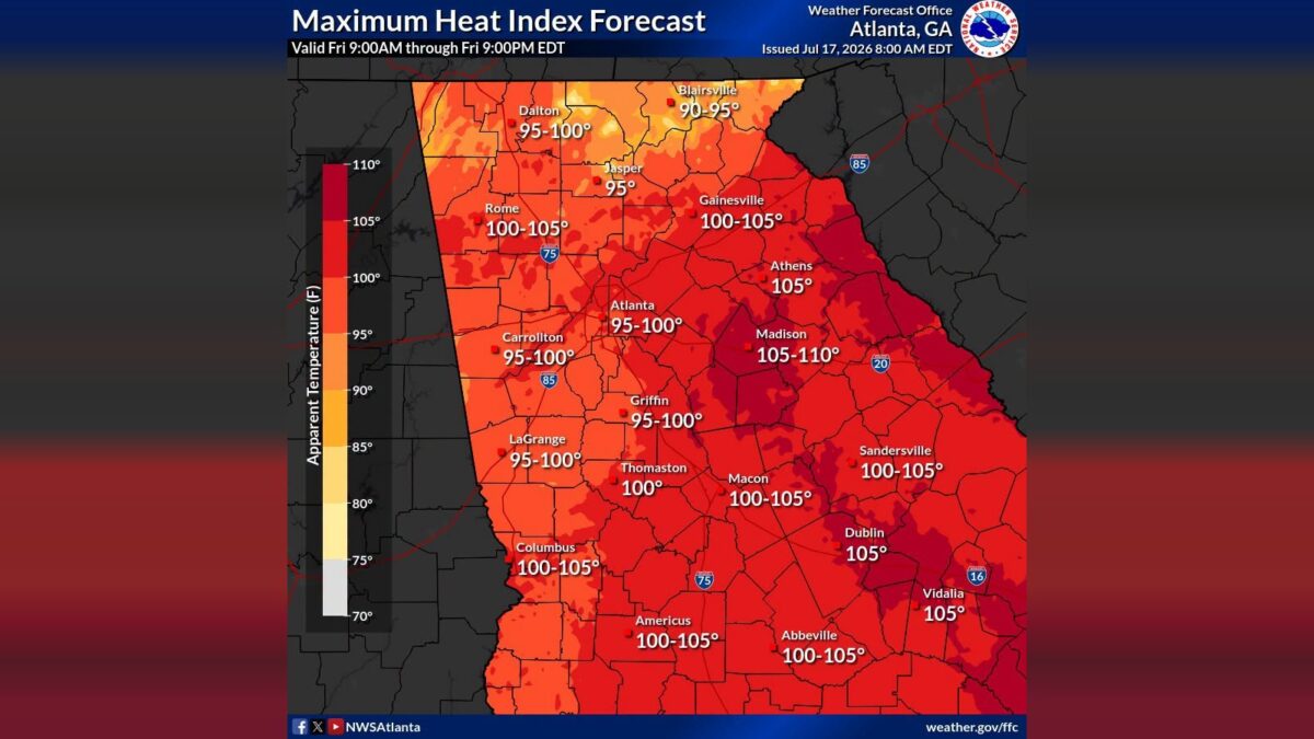
The heat: A Heat Advisory is in effect from noon to 8 p.m. across eastern Georgia. A Heat Advisory was issued when the combination of heat and humidity becomes dangerous to your health. The heat index — what the air actually feels like on your skin once humidity is factored in — is forecast to hit 100 to 108°F across much of the state. Madison, in east-central Georgia, is expected to see the worst of it, with readings between 105 and 110°F. Athens, Dublin, and Vidalia are each forecast to reach 105°F. Atlanta is expected to feel between 95 and 100°F.
What this means for you: Anyone outside today faces two separate risks: heat illness during the afternoon hours and the chance of being caught in a fast-moving storm. The National Weather Service says to stay hydrated, have more than one way to receive weather alerts, and be ready to head inside quickly if storms approach.
The path forward: Both the storm threat and the Heat Advisory are expected to end by 8 to 9 p.m. tonight.

B.T. Clark is the Publisher of The Georgia Sun and author of Principles Are Like Pants… You Ought to Have Some. Over two decades in journalism, he has served as Managing Editor of Neighbor Newspapers in metro Atlanta and Digital Director at Times-Journal Inc., earning multiple awards along the way. His work has appeared in newspapers across the state, including The Cherokee Tribune and The Marietta Daily Journal.
- B.T. Clark

- B.T. Clark

- B.T. Clark

- B.T. Clark