
Snow is expected across Georgia beginning Friday night, with the heaviest accumulations forecast for the state’s northern mountains.
What’s Happening: The National Weather Service has issued winter storm warnings for six north Georgia counties, where 2 to 4 inches of snow is expected between 7 p.m. Friday and 1 a.m. Sunday. Winter weather advisories cover an additional 20 counties across north and central Georgia, where up to 2 inches of snow is forecast.
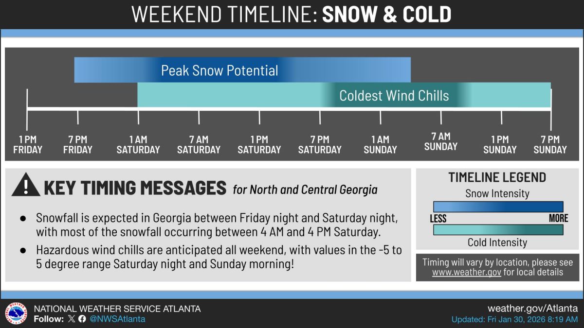
What’s Important: Most snowfall will occur between 4 a.m. and 4 p.m. Saturday. Roads and bridges are expected to become slick and hazardous as snow rapidly sticks to surfaces due to temperatures in the 20s. Wind gusts up to 35 mph could cause blowing snow and poor visibility.
How This Affects Real People: Travel is expected to be very difficult to impossible in warning areas and difficult in advisory areas. Water pipes could rupture during extended freezing temperatures. Residents should wrap, drain, or allow pipes to drip slowly and protect outdoor pets and tender plants.
The Path Forward: The dangerous cold will persist beyond the snow. Wind chills are forecast to drop as low as 5 below zero to 5 above zero in some areas Saturday night and Sunday morning, creating conditions where frostbite can occur on exposed skin in as little as 30 minutes. This extreme cold pattern could strain heating systems and increase risks for vulnerable populations, particularly if power outages occur in areas with heavy snow accumulation.
Winter Storm Warnings: Fannin, Union, Towns, Lumpkin, White, and Dawson counties are under winter storm warnings from 7 p.m. Friday to 1 a.m. Sunday. These counties could see 2 to 4 inches of snow with locally higher amounts possible.
Winter Weather Advisories: Dade, Walker, Catoosa, Whitfield, Chattooga, Gordon, Floyd, Murray, Gilmer, and Pickens counties are under advisories from 7 p.m. Friday to 7 p.m. Saturday. Cherokee, Cobb, North Fulton, South Fulton, DeKalb, Rockdale, Newton, Clayton, Henry, Butts, Jasper, Jones, Twiggs, Wilkinson, Bartow, Polk, Paulding, Haralson, Carroll, and Douglas counties are under advisories from 1 a.m. to 7 p.m. Saturday. These areas could see up to 2 inches of snow.
Central Georgia: Forsyth, Hall, Banks, Jackson, Madison, Gwinnett, Barrow, Clarke, Oconee, Oglethorpe, Wilkes, Walton, Morgan, Greene, Taliaferro, Putnam, Hancock, Warren, Baldwin, Washington, Glascock, and Jefferson counties are under winter storm warnings from 1 a.m. Saturday to 1 a.m. Sunday, with 2 to 4 inches of snow expected.
East Central Georgia: Lincoln, McDuffie, Columbia, Richmond, and Burke counties in Georgia, along with portions of South Carolina, are under winter storm warnings from 10 p.m. Friday to 10 a.m. Sunday. These areas could see 3 to 6 inches of snow.
Extreme Cold Watches: Southeast Georgia counties including Coffee, Jeff Davis, Bacon, Appling, Wayne, Atkinson, Pierce, Brantley, Echols, Clinch, and Ware are under extreme cold watches from Saturday evening through Sunday afternoon. Wind chills could drop as low as 5 to 6 above zero. Freeze watches are also in effect for these areas, with temperatures as low as 18 degrees possible.
Safety Guidance: The National Weather Service advises residents to delay all travel if possible. Those who must go outside should dress in layers including a hat, face mask, and gloves. Young children, the elderly, and homeless individuals are especially vulnerable to the cold. Residents should check on older family, friends, and neighbors. Portable heaters should be used correctly, and generators or grills should never be used indoors.

ON SNOWPOCALYPSE:
“Like most metro Atlanta residents at the time, I dismissed the warnings and scoffed at the meteorologists who cried “snow” at the drop of a thermometer. After all, in Atlanta, snow forecasts are as reliable as Hollywood marriages. The reflexive grocery stampedes for bread, milk, and eggs seemed like a seasonal ritual more for omelet enthusiasts than survivalists.”
