
The National Weather Service forecasts hazardous travel conditions and possible power outages across Georgia beginning Saturday evening and continuing through Monday morning.
What’s Happening: A winter storm will bring freezing rain, sleet and ice accumulation to multiple regions of Georgia. The National Weather Service issued the forecast Friday afternoon. Impacts to travel will begin Saturday evening and continue Sunday.
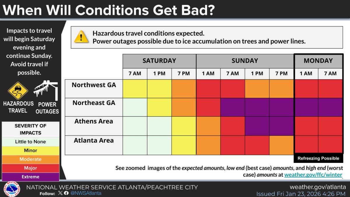
What’s Important: The worst conditions are expected Sunday into Monday morning for all affected areas. Power outages are possible due to ice accumulation on trees and power lines. The National Weather Service advises avoiding travel if possible.
When Conditions Will Worsen in Your Area: The severity and timing of impacts varies by region across Georgia.
Northwest Georgia will see minor impacts Saturday morning at 7 a.m., worsening to moderate impacts by 7 p.m. Saturday. Conditions will deteriorate to major impacts from 1 a.m. Sunday through 7 a.m. Sunday, then moderate impacts at 1 p.m. and 7 p.m. Sunday. Major impacts return from 1 a.m. Monday through 7 a.m. Monday.
Northeast Georgia will experience little to no impacts at 7 a.m. Saturday, minor impacts at 1 p.m. Saturday, and moderate impacts by 7 p.m. Saturday. Conditions will worsen to major impacts at 1 a.m. Sunday, then extreme impacts from 7 a.m. Sunday through 7 p.m. Sunday. Extreme impacts continue at 1 a.m. Monday, with major impacts at 7 a.m. Monday.
The Athens area will see little to no impacts at 7 a.m. Saturday, minor impacts at 1 p.m. Saturday, and minor impacts at 7 p.m. Saturday. Conditions will worsen to moderate impacts at 1 a.m. Sunday, major impacts at 7 a.m. Sunday, then extreme impacts from 1 p.m. Sunday through 7 p.m. Sunday. Major impacts are forecast for 1 a.m. and 7 a.m. Monday.
The Atlanta area will experience little to no impacts at 7 a.m. Saturday, little to no impacts at 1 p.m. Saturday, and minor impacts by 7 p.m. Saturday. Conditions will deteriorate to moderate impacts at 1 a.m. Sunday, major impacts at 7 a.m. Sunday, major impacts at 1 p.m. Sunday, and moderate impacts at 7 p.m. Sunday. Major impacts return at 1 a.m. and 7 a.m. Monday.
The Severity Scale: The National Weather Service uses a five-level severity scale. Little to none means minimal impacts. Minor means some impacts. Moderate means noticeable impacts. Major means significant impacts. Extreme means the most severe impacts.
How This Affects Real People: Drivers across Georgia will face dangerous road conditions this weekend. Ice accumulation could cause power outages, leaving residents without electricity during freezing temperatures. Refreezing is possible Monday morning.
The Path Forward: Due to the cycle of melting and refreezing, impacts may continue to some degree into next week. The National Weather Service warns that conditions will worsen throughout the weekend before improving.

ON SNOWPOCALYPSE:
“Like most metro Atlanta residents at the time, I dismissed the warnings and scoffed at the meteorologists who cried “snow” at the drop of a thermometer. After all, in Atlanta, snow forecasts are as reliable as Hollywood marriages. The reflexive grocery stampedes for bread, milk, and eggs seemed like a seasonal ritual more for omelet enthusiasts than survivalists.”
