
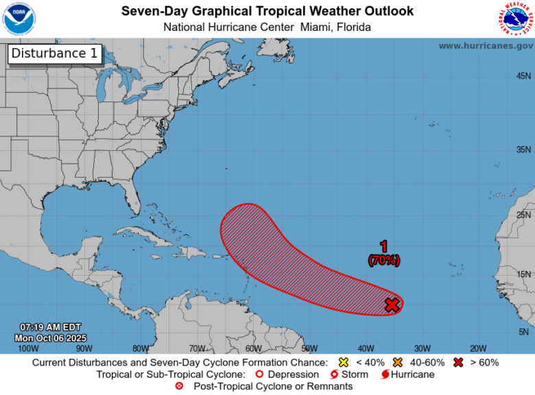
A sprawling mess of thunderstorms is organizing itself into something more dangerous over the central Atlantic, moving fast toward the Caribbean.
🌊 Why It Matters: By late this week, this system could be knocking on the door of Caribbean islands that have seen their share of storms. The National Hurricane Center gives it a 70 percent chance of becoming a tropical depression within seven days.
⚡ What’s Brewing: A broad low-pressure system tied to a tropical wave is throwing off disorganized showers and thunderstorms across the central Atlantic. The conditions around it look favorable for development. Not perfect, but good enough.
The system is moving quickly west-northwest. That’s the track that matters. It’s headed straight for the northern Leeward Islands. If the system becomes a tropical storm, it will become Tropical Storm Jerry.
⏰ The Timeline: Within 48 hours, forecasters put the odds at 50 percent that this thing organizes into something more coherent. By the end of the week, those odds jump to 70 percent.
The National Hurricane Center issued its outlook Monday morning from Miami.
🌀 What This Means For Georgia: Nothing yet. The system is still days away from the Caribbean, and any potential threat to the southeastern United States remains purely speculative. But October storms have a way of surprising people. The water is still warm. The season isn’t over.
For now, this is a Caribbean problem. But it’s worth watching.
📋 The Sources: National Weather Service, National Hurricane Center.

B.T. Clark is the Publisher of The Georgia Sun and author of Principles Are Like Pants… You Ought to Have Some. Over two decades in journalism, he has served as Managing Editor of Neighbor Newspapers in metro Atlanta and Digital Director at Times-Journal Inc., earning multiple awards along the way. His work has appeared in newspapers across the state, including The Cherokee Tribune and The Marietta Daily Journal.
- B.T. Clark
- B.T. Clark
- B.T. Clark

- B.T. Clark