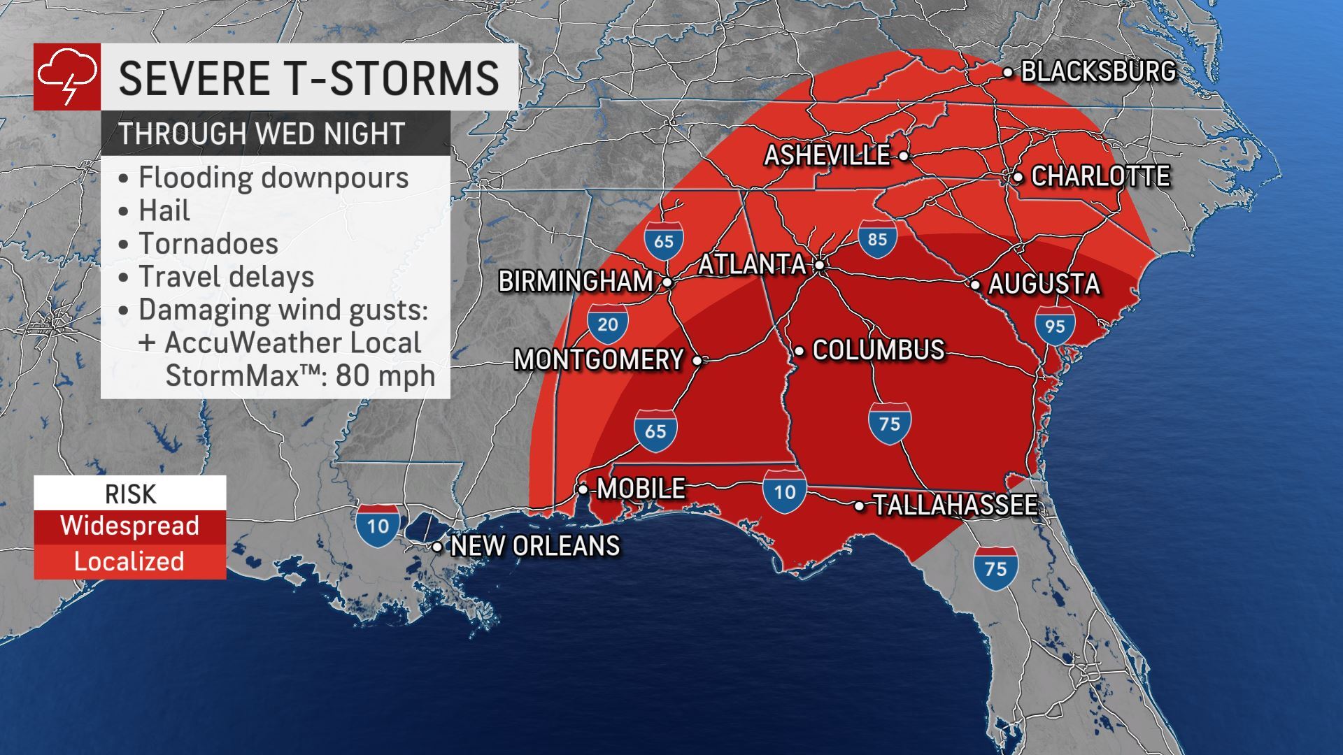
Residents in part of the Southeast will face more volatile weather into Wednesday night that will include the risk of tornadoes. AccuWeather meteorologists say the risk of flash flooding will also be heightened as a result of the rounds of stormy weather so far this week.
A tornado touched down in Bryan County Tuesday evening.
A large storm over the North Central states will begin to pull warm and humid air northward from the Gulf of Mexico once again and limit the break from severe weather to less than 24 hours in parts of the Southeast, following deadly, damaging thunderstorms that brought dozens of tornadoes and flash flooding Tuesday.
The most significant threat for tornadoes will extend from portions of central and southern Alabama to Georgia, South Carolina and northern Florida into Wednesday night. However, all facets of severe weather are possible in this zone ranging from high winds and hail to flash flooding. The severe weather threat and the potential for a few tornadoes also extends farther to the north and includes areas from eastern Tennessee, southeastern Kentucky and part of West Virginia, as well as western Virginia.
“While April often denotes a strong uptick in severe weather, Gulf of Mexico waters are running well above average for this point of the season, and that could mean that storm systems will have the potential to trigger even more severe weather and tornadoes than one might expect,” AccuWeather Lead Long-Range Meteorologist Paul Pastelok said.
The severe weather threat will linger for the entire day and into Wednesday night for locations south of Interstate 20. In areas farther to the north in Alabama, Georgia, South Carolina and North Carolina, severe thunderstorms are likely to hold off until after dark and may not move through until the middle of Wednesday night.
Heavy to locally severe storms may also extend northward over parts of the Ohio Valley and perhaps as far to the north as the shores of Lake Erie.https://embed.acast.com/621d493fbd6e6f0012aa5a66
Powerful wind gusts can easily occur within large complexes of thunderstorms, and an AccuWeather Local StormMax™ of 80 mph will be possible. At this force, sporadic power outages and property damage can occur along with an elevated risk of trees being knocked over due to saturated ground.
The risk of flash flooding is likely to be greatest in locations that got doused Tuesday and where thunderstorms move over the same areas for several hours.
The severe thunderstorm and flash flooding threats include many major cities along the I-85 corridor from Montgomery, Alabama, to Atlanta and Charlotte, North Carolina. For some cities, Wednesday could be the second consecutive day with severe thunderstorms or flash flooding.
Motorists traveling on major interstates throughout the region should be prepared to face slowdowns as sudden visibility reductions occur from the downpours and blowing spray from other vehicles. Secondary roadways may be blocked by fallen trees and power lines or floodwaters, forcing motorists to take an alternate route.
The risk of severe weather may not come to an end Thursday.
As a cold front spirals eastward from the large storm over the North Central states, heavy, gusty thunderstorms, perhaps a few with damaging winds, may erupt from the eastern parts of the Carolinas to as far to the north as Maryland, Delaware and southern New Jersey. The greatest risk of thunderstorms capable of producing tornadoes is likely to extend from eastern North Carolina through southeastern Virginia.
A second zone of severe weather will be possible on Thursday as a cold front pushes southward through Florida, forecasters say. The northern and central portions of the Peninsula, which includes the cities of Tampa and Orlando, will be at risk for storms that could unleash high winds, flash flooding and hail.
As AccuWeather meteorologists predicted since last week, April has picked up right where March left off as severe weather got underway late Monday across the southern Plains, with dozens of reports of hail and damaging winds from the Texas-Oklahoma border to southern Arkansas and northern Louisiana. AccuWeather National Reporter Bill Wadell was on the scene in Alvarado, Texas, where lightning strikes sparked numerous fires across the town.
The storms from the beginning of the week shifted eastward throughout Tuesday, spawning over three dozen preliminary tornadoes in Mississippi, Alabama, Georgiaand South Carolina, according to the Storm Prediction Center. Flash flooding was also reported across southern Mississippi as the thunderstorms unleashed localized amounts of 3-6 inches.
Forecasters say there is some good news as several days of quieter weather conditions are likely for the Southern states beginning Friday as unseasonably cool air takes hold and lasts through the weekend. The next round of severe weather may then begin to unfold early next week over the southern Plains.
- Here Are The Significant Changes to Health Care in Georgia That Were Just Signed Into Law
- Construction Worker Dead After His Vehicle Collided With a Bridge on I-475 in Macon
- Marjorie Taylor Greene Has Raised Nearly $5 Million in Her Congressional Campaign
- 21-Year-Old Arrested After Ramming Stolen Vehicle Into Gwinnett Police Patrol Car
- Why Does Georgia Make Your Driver’s License and Vehicle Registration Due on Your Birthday?
Disclosure: This article may contain affiliate links, meaning we could earn a commission if you make a purchase through these links.


